Mooiste langeafstandspaden
Mijn selectiecriterium voor een mooie langeafstandswandeling (of het mooiste deel ervan) is dat de route minimaal drie dagen door aantrekkelijk landschap voert. Daarnaast is een goede markering in het terrein en een duidelijke kaart met ingetekende routelijn vanzelfsprekend – zo kun je zorgeloos genieten.
De Coast to Coast Walk is compleet behandeld, van de anderen alleen het mooiste deel.
Public Foothpaths & Stiles
Engeland is het land van de public footpaths en karakteristieke stiles (overstapjes).
In het ruige noorden wandel je over uitgestrekte moors, robuuste bergen en door groene dalen waar je langs weilanden met eeuwenoude stenen muurtjes komt.
In het wat toeristischere zuiden vind je iconische kustwandelingen, waaronder het beroemde pad langs de Jurassic Coast. Ook tref je daar zacht glooiende, asymmetrische heuvels aan – zogenoemde cuesta’s – zoals die in de South Downs en de schilderachtige Cotswolds.
Kortom: trek je wandelschoenen aan en ontdek het gevarieerde Engelse landschap!
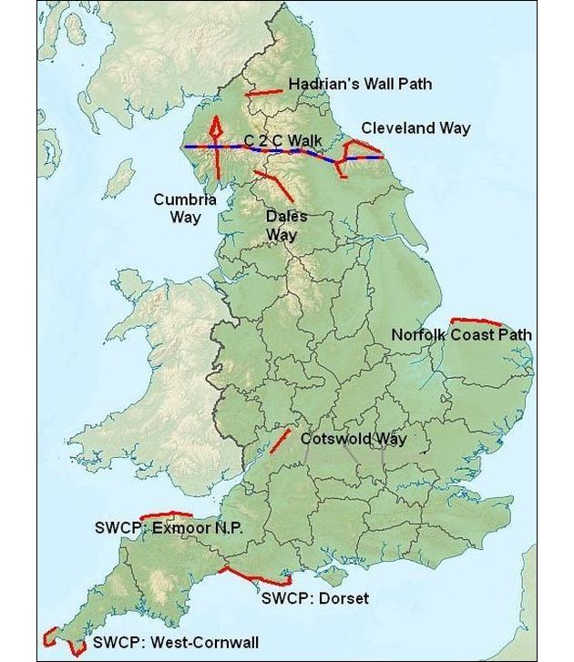
Top trails Noord-Engeland
(in alfabetische volgorde)
Cleveland Way (national trail)
Deeltraject Helmsley — Whitby 124km
Het is een hoefijzervormige route rond het North York Moors-plateau. Daarbij loop je eerst over een panoramapad langs de westelijke plateaurand, en vervolgens over een kustpad bovenlangs de klif.
The Cleveland Way is a horseshoe-shaped route around the edge of the North York Moors National Park.
Beginning in the old market town of Helmsley, the trail follows the western escarpment (=cuestafront) of the North York Moors to meet the coast at Saltburn-by-the-Sea, and then takes in a section of the North Yorkshire and Cleveland Heritage Coast to finish at Whitby.
Coast to Coast Walk (géén national trail)
St Bees — Robin Hood’s Bay 309km
Géén national trail, maar wel het mooiste pad van Groot-Brittannië !
Created by Alfred Wainwright, the Coast to Coast Walk crosses the North of England from the Irish Sea at St Bees to the North Sea at Robin Hood’s Bay.
The route passes through some of the most beautiful and varied scenery in the country:
- the rugged mountains and beautiful lakes of the Lake District,
- the rolling hills and pretty valleys of the Yorkshire Dales and
- the expansive heather moorland of the North York Moors,
- with some dramatic coastal scenery at each end.
Cumbria Way (géén national trail)
Deeltraject Ulverston — Caldbeck 90km
Géén national trail, maar wel zeer mooi. Men loopt van zuid naar noord door het Lake District.
The Cumbria Way runs through the heart of the Lake District from the attractive market town of Ulverston to Caldbeck. Along the way it passes through some of the finest scenery of this much loved area.
The Cumbria Way is essentially a low-level walk through the Lake District.
It follows old packhorse tracks along valleys and over passes and provides breathtaking mountain views without actually going to any of the summits.
Dales Way (géén national trail)
Deeltraject Bolton Abbey — Sedbergh 76km
Géén national trail, maar wel zeer mooi.
Beginning at Bolton Abbey, the Dales Way follows the River Wharfe, past the romantic ruin of Bolton Priory and the pretty villages of Burnsall, Grassington, Kettlewell and Buckden.
Beyond Cam Fell, the trail follows the River Dee through Dent and on to the old market town of Sedbergh.
Hadrian’s Wall Path (national trail)
Deeltraject Brampton — Corbridge 74km.
Following the central part of the old Roman frontier of Hadrian’s Wall with stunning countryside.
In AD 122 Emperor Hadrian ordered the construction of a wall across. northern England to hold back the advancing Barbarians.
Despite the depredations of the centuries, Hadrian’s Wall remains the largest ancient monument in northern Europe and the best way to appreciate it, and the ruggedly beautiful countryside around it, is to walk it, following in the footsteps of the Legionnaires.
Northumberland Coast Path (was voorheen géén national trail)
Deeltraject Bamburgh — Warkworth 41½km.
Het is een van de mooiste stukken van de Britse noordoostkust. Tevens is het een van de rustigste kustgebieden, omdat het klimaat hier niet direkt uitnodigend is voor strandtoeristen. Het zeewater is behoorlijk koud en de zandstranden liggen meestal nogal onbeschut. Des te beter is de kust geschikt voor wandelingen over de stranden, door de duinen en boven over de lage kliffen.
The Northumberland coast AONB is one of England’s finest unspoilt coastal stretches, characterized by:
- sandy beaches (and dunes) with,
- imposing castles perched on rocky headlands, and
- picturesque old coastal villages having hardly been changed by time,
- wildlife rich off-shore islands.
There are few real cliffs, and if the tide is favourable you can wander the open sand for long stretches.
Top trails Zuid-Engeland
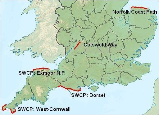
(in alfabetische volgorde)
Cotswold Way (national trail)
Deeltraject Chipping Campden — Dursley 124km
It runs along the western edge of the Cotswold Hills. from the beautiful old ‘wool’ town of Chipping Campden to Dursley.
Between the two it follows a meandering course along the western escarpment (=cuestafront) where the land drops suddenly to reveal distant views (het is dus een panoramapad !),
through beech woodland, along the banks of mill-streams, across crops and pastures and sheltered valleys concealing picturesque villages built from mellow, honey-coloured stone.
Norfolk Coast Path (national trail)
Deeltraject Hunstanton — Cromer 75km
(Norfolk rekent men ook bij Zuid-Engeland; West- en East Midlands vormen Midden-Engeland))
This section of the Norfolk Coast Path has only some low, crumbling cliffs.
More important are the vast tracts of saltmarshes (= kwelders) riddled with creeks.
There are also wide sandy beaches backed by dunes and a constantly shifting shingle bank (=kiezelwal) Blakeney Point.
Numerous villages/towns, which were once busy ports, are now separated from open water by the saltmarshes and tidal flats.
Their small harbours are nowadays ‘sea’ at high tide, and mudflats at low.
South West Coast Path (national trail)
Het is de langste National Trail in de UK 1008km.
Drie deeltrajecten hebben top trail kwaliteit:
- Seaton — Poole 125 ½ km (Dorset)
- Zennor — Helford 119 km (West Cornwall)
- Minehead — Woolacombe 78 km (Exmoor).
Je eerste langeafstandspad in Engeland
Dan lijkt me de Cleveland Way heel geschikt. Dit pad :
- is niet al te lang (7 dagen met een dagrugzak),
- mooi gevarieerd, en
- heeft normaal gesproken ’s zomers goed weer.
Wandelaars en grote grazers
Er zijn jaarlijk incidenten tussen wandelaars en grote grazers (runderen en paarden). Let daarom goed op als je door een weiland loopt met grote grazers. Zij zijn daar de baas en niet jij. Doe als volgt:
1. Houd 50 m afstand, óók als dieren naar je toekomen.
2. Blijf de dieren aankijken. Keer ze dus niet de rug toe.
3. Lijn de hond aan. Loslopende honden veroorzaken onrust.
Vertrouw je het gedrag van een of meerdere dieren niet, maak dan rechtsomkeer en zoek m.b.v. je kaart een andere route.
National trails
Dit is een selecte groep paden die door de nationale overheid financieel gesteund worden. Ze hebben daardoor:
- een zéér goede markering in het terrein (en voorzieningen als overstapjes) en
- een uitstekende wandelgids.
Route-finding is bij hen dan ook geen enkel probleem.
De overige paden hebben soms een minder goede markering.
Ze zijn echter niet minder mooi. De Coast to Coast Walk is zelfs het allermooiste pad van Groot-Brittannië.
Pennine Way
Dit is geen gewoon langeafstandspad. Het voert door een woest terrein met allerlei problemen. Denk aan: slecht weer, modderige paden, miljarden midges (knutjes), etc.
Advies:
1. Loop eerst de Coast to Coast Walk en de Dales Way. Je steekt dan halverwege die routes de Pennines over. Hierdoor krijg je een goede indruk van dat terrein. Je kunt dan beter beoordelen of dit langeafstandspad wel geschikt voor je is.
2. Als je het toch wilt gaan doen, loop dan dit langeafstandspad in afzonderlijke gedeelten tijdens periodes met goed weer. Verlaat dus het gebied bij weersverslechtering en kom een andere keer terug om de draad weer op te pakken. Veelal heb je dus een aantal jaren nodig, waarin je telkens een gedeelte kunt lopen.
The Pennine Way 268 miles ( 429 km) is generally regarded as the toughest, most demanding, and most challenging long-distance walk in Britain. Of all the National Trails, the Pennine Way climbs higher and stays higher for longer than any of the other routes. That’s true enough, but it’s something more than that. It’s adventurous, exciting and rewarding as well.
There is nothing technically difficult about the Pennine Way – you won’t find yourself dangling off ropes, clinging to rock faces or staring down terrifying abysses, and there are really only three ascents worthy of special mention.
The challenge is, essentially, a mental and a logistical one.
Your adversaries on this walk are:
1. the terrain,
2. the climate and
3. the awesome sense of loneliness
Geography
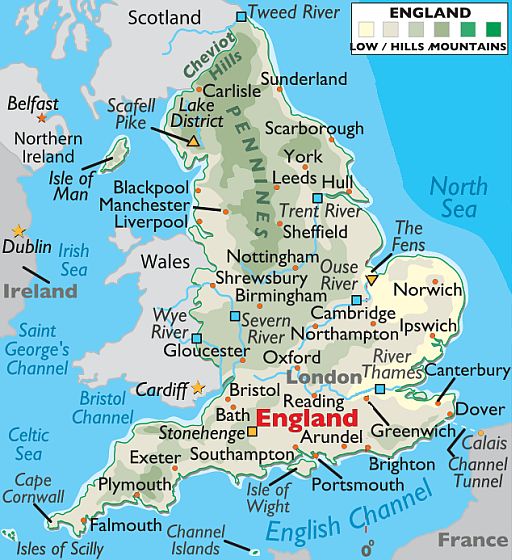
England is divided central and north by the Pennines, a low mountain range that stretches for almost 400 km, from Birmingham north into the Cheviot Hills on the Scottish border.
In the far northwest corner of the country – within the Lake District – the highest point in the county, Scafell Pike , stands at 978 m.
With a few exceptions, the balance of England’s land, central and south, is a series of rolling hills, punctuated by undulating lowlands.
In the east-central region of the country, the Fens (or Fenlands) is an area of flat, low-lying marshland drained for agricultural use.
The lowest point in the country is found there, at -4 meters below sea level.
In the southeast, chalk cliff front the Dover coastline and most of Dorset County.
In the far southwest (at Land’s end), rugged cliffs and jagged rocks greet Atlantic Ocean waves.