a
30. High Cup Nick
67. Forest of Bowl..
70. Sandstone Trail
82. Another Place
86. Witches Trail
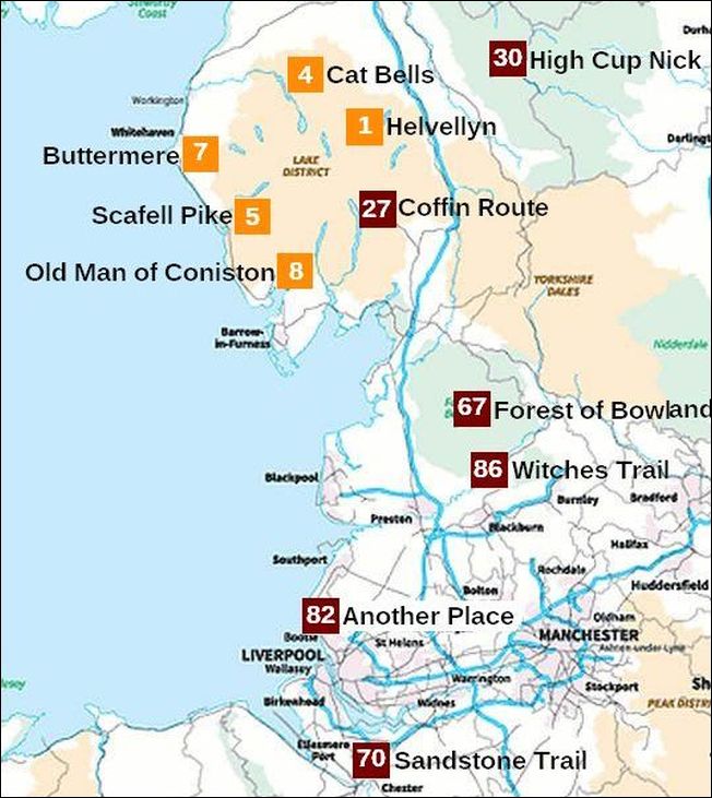
Uitleg bij de kaart
Nummer 4 betekent dat deze wandeling op de 4de plaats eindigde in Britain’s Favourite Walks: Top 100 gekozen op ITV.
De wandelingen uit de Top 10 (in die Top 100) zijn oranje.
Lichtbruin = National Park
Lichtgroen = AONB (Area of Outstanding Natural Beauty) (the next step down from a National Park).
De North Pennines AONB (in lichtgroen) zit alleen met het westelijke deel in de regio North West England. In de bovenstaande kaart zie je daar nummer 30 High Cup Nick.
Het Yorkshire Dales National Park daaronder in lichtbruin behoort er niet toe. Dat zit in de regio Yorkshire & The Humber.
Lake District is uniek
Op de kaart zie je hoe uniek het Lake District is met maar liefst 5 wandelingen in de Top 10.
Het is een fantastisch gebied voor een wandelvakantie. Alleen het weer gooit soms roet in het eten.
The Lake District – a glaciated upland
The Lake District is England’s highest upland, with mountains rising to almost 1000 m (highest mountain Scafell Pike = 978 m).
(upland = all land above the upper limit of enclosured (=omheind) farmland.
Dit is grofweg het gebied hoger dan 1,000 feet (ongeveer 300m).
It is also the countries best example of a glaciated upland, with much evidence of a variety of glacial features including ribbon lakes (langgerekte meren) for which the area is famous.
As with all of our mountain regions, the Lake district used to be much, much higher than it is now, but it has been weathered and eroded by many forces, and especially by glaciers.
During the Ice Age, glaciers spread out in all directions from the highest part of the Lake District and eroded a trail of features including:
– corries (=karen) met tarns (=kaarmeertjes)
– arêtes (=graten)
– pyramidal peaks (=pyramidale pieken),
– U-shaped valleys (=dalen met U-vormig dwarsprofiel), met daarin:
– ribbon lakes (=langgerekte meren)
(most famous of these lakes being Lake Windermere (longest lake in Engl.)
Zie ook de volgende uitgebreide introducties:
glaciated upland landscapes en uplands
1
1. Helvellyn (950m)
(via Striding Edge) Lake District
5-6 uur
halfzwaar/zwaar
A thrilling mountain route. Helvellyn’s ridges are exciting, only a little bit scary, but great fun.
Helvellyn is so much more than England’s third highest mountain, and it was no surprise when this route was voted Britain’s Favourite Walk in a 2017 ITV poll.
An ascent of this 950m peak via the narrow ridge (= graat) of Striding Edge is one of Britain’s most iconic mountain challenges, mixing hill walking with scrambling on a spectacular route that requires the use of hands in a few places – and a good head for heights!
The classic way to walk Helvellyn is from the village of Glenridding, first climbing steeply over Birkhouse Moor with wonderful views down the Ullswater valley, then tackling the Grade 1 scramble of Striding Edge all the way to Helvellyn’s vast summit plateau
Scrambling (= klauteren, klimmen)= Using hands (as well as feet) to negotiate a steep, rocky section of path.
After tucking into celebratory sandwiches and enjoying views across what feels like the entire Lake District National Park, descend from the summit via Swirral Edge – another steep rocky scramble that feels intimidating when you first tiptoe towards it.
At the low point of the Swirral Edge ridge, follow the path that leads down towards the impressive glacial bowl (=kaar) containing Red Tarn then follow the obvious path down the valley to Glenridding.
IMPORTANT: If you aren’t comfortable with heights or exposed mountain terrain, this route may not be suitable for you. There are less technical routes up Helvellyn on footpaths suitable for walkers of all ages and abilities.

Rother Wandelgids ‘Noord-Engeland’, Tour 58 gaat door Grisedale.
Dan is het géén Top-Tour. Doe dat daarom niet. Ga liever via Striding Edge en Swirral Edge, zie kaartje hieronder.
In dat geval heb je een spectaculaire route die toch voor vrijwel iedereen goed te doen is. Ze is zeer bijzonder. Ze werd nummer 1 in Britain’s favourite walks TOP 100.
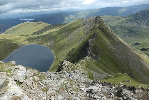
Vanaf Helvellyn kijk je hier neer op het kaarmeer Red Tarn en rechts daarvan de graat Striding Edge.
Helvellyn is without a doubt one of the most popular mountains in the Lake District. Just like the best mountains around, it has many great routes to its summit, but one stands head a shoulders above the rest, and that is via Striding Edge.
Striding Edge is a spectacular knife edge arete (=graat) that offers a breathtaking scrambling experience. From climbing across blocks, walking across a narrow crest, and down climbing ‘The Chimney’, Striding Edge has it all. To the left of Hellvellyn is corrie lake Red Tarn.
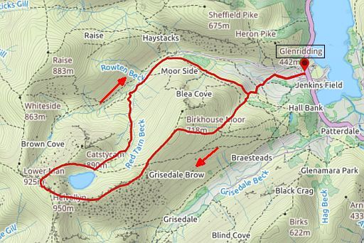
Start/Finish:
Glenridding.
Wildkamperen (bivak):
Gaf geen problemen.
Goede introducties:
Verdere info:
Wandelgids
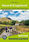
Rother Wandelgids ‘Noord-Engeland’
Sabine Gilcher
Elmar Uitgeverij.
Tocht 58 Helvellyn (950m)
De tocht via Striding Edge behoort tot de mooiste wandelingen van dit wandelgidsje (zie lijst blz. 9).